Closing in
0
...
Menu
Search
LATEST
POPULAR
AIRCRAFT FOR SALE
SECTIONS
Business Aviation
Aerospace & Defense
Rotorcraft
General Aviation
FutureFlight
SUSTAINABILITY & ENVIRONMENT
CHANNELS
Aircraft
Maintenance
Avionics
Charter & Fractional
Safety
All Categories
News Archive
Newsletter Archive
MORE
Print Archives
Expert Opinion
In-Depth Reports
Videos
Webinars
Airshows & Conventions
Aviation Events
Compliance Countdown
Whitepapers
ABOUT
About AIN
Our Writers
History
Advertise
Contact Us
Subscribe
LATEST
POPULAR
AIRCRAFT FOR SALE
SECTIONS
ABOUT
Search
Subscribe
Search
Safety
WSI Unveils Updated Pilotbrief Weather Product at NBAA 2013
Share
Post
Share
Print
Copy
Email
By
James Wynbrandt
• Contributor - Business Aviation
October 25, 2013
More In Safety
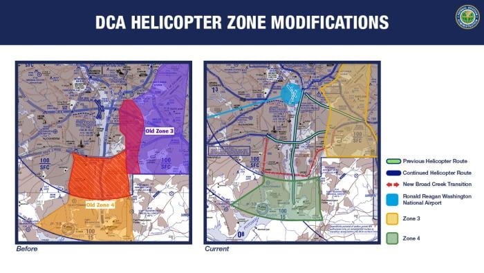
Critics Say NDAA Could Undermine D.C. Airspace Safety
Legislation would allow waivers for transponder use, and it doesn’t require ADS-B
Safety
Vision System Helps Airport Emergency Responders
Fusion Vision System uses augmented reality thermal imaging
Safety
2025 Became a Reckoning Year for Air Safety
Industry confronted systemic gaps revealed by tragedy
Safety
Upset Safety Virtual Event Scheduled in December
December 17 event focuses on loss of control in-flight events and training strategies
Safety
EASA Safety Conference Warns Against Complacency
The conference was held in the Danish capital Copenhagen earlier this month
Safety
SFBAA Charity Golf Outing Provides Immediate Assistance
Annual event assisted a young cancer patient in need of transcontinental transport.
Safety
FAA Issues Security Notam for Venezuelan Airspace
Notam, effective through February 19, cites worsening security and GNSS interference
Safety
Daher Aircraft Outlines Safety Initiatives at TBMOPA Event
Safe Horizons initiative expands TBM safety resources
Safety